School planners and administrators need a lot of resources to effectively run a district. One beneficial way to do this is by using geographic information systems (GIS), like those offered by Geographic Information Solutions, LLC. GIS is a system that uses information on location (including longitude, latitude, addresses, and zip code) and helps organizations understand the relationship between location and spatial patterns.
However, GIS collects more than just spatial data. It can also collect demographic data like population, average income, and education levels, which helps school districts with crucial planning, and GIS software can store infrastructure information to distinguish between the sites of factories, farms, schools, roads, power lines, and more. (It will also determine landscape features like bodies of water and their location, vegetation, and types of soil in those particular areas.)
Data collection from GIS technology then provides a layered map. One layer pulls from street data to provide a roadmap of the area. Another layer pulls from the building data to show where exactly infrastructure is located throughout the selected location. The final layer pulls from the vegetation dataset to map out the different types of plant life and foliage. Finally, all three maps overlay on each other to produce the integrated map showing the streets, buildings, and vegetation altogether for easy visualization of the location.
Facility Planning Made Easy
GIS data can help school planners make vital decisions about their districts (such as facility planning). Looking to add or build a new school to the district? Demographic data presented from GIS maps can help determine the best location for the new school site, as well as assist in enrollment projections to determine capacity needs.
Knowing the population of the district also helps determine how many elementary schools, middle schools, or high schools are needed to fit the needs of the people. This spatial analysis can also aid in administrative decisions like how many school board members are needed for the size of the district.
Because GIS maps can store infrastructure information, school planners can also conduct data analysis on the types of buildings in the district and their conditions. GIS maps display the conditions of buildings, which allows school districts to easily keep track of when to schedule repairs and rebuilds.
When it comes to redistricting or adjusting attendance boundaries, GIS maps are a crucial planning tool for GIS analysis. They allow school officials to view and examine student populations (helping to determine where new school facilities should be built, based on dense population sites, and where wide school boundaries may hinder enrollment).
Streamline Your Planning Process with BEST (Boundary Exploration & Scenario Testing)
Need help determining if a new or adjusted attendance boundary is beneficial? Have the data at your fingertips. The BEST Redistricting Tool makes adjusting school boundaries easy. If you’re expanding, consolidating, or shifting demographics, this tool helps navigate the process, because both large and small districts face challenges when exploring adjustments within their community.
The BEST Redistricting Tool from Geographic Information Solutions, LLC collects data and allows you to test out different boundary lines early in your planning process. There are a lot of risks associated with adjusting districts. Remove uncertainty by testing out scenarios and comparing data of all potential school boundaries.
Design Efficient Bus Routes
Students’ accessibility to get to school is another priority in school planning, with proper bus routes and transportation plans. Using a stored geodatabase, school planners can determine the best routes for their buses to take. Street data provides accurate information on the roads throughout the district, and the demographic data shows where students live. Using this dataset aids decision making on transportation to make the most logical path and avoid overcrowding busses.
Prior to this technology, a master plan for transportation would take hours to form, even for small districts. School planners would have to calculate the distance for each student in the attendance boundary to their respective school. (The system would be even more complicated by having to use paper or printed maps.) This manual method is more time consuming but also less accurate, since physical or static maps can easily be outdated as things change in the area. Additionally, demographic data would have to be collected by using resources such as phone books, which could easily be rendered useless as things change.
GIS maps, by comparison, store this data and are easily updated to stay accurate, both with landscape and people. Having accurate demographic data not only makes bus route planning easier to organize, but also guarantees that students are going to the closest school to their area.
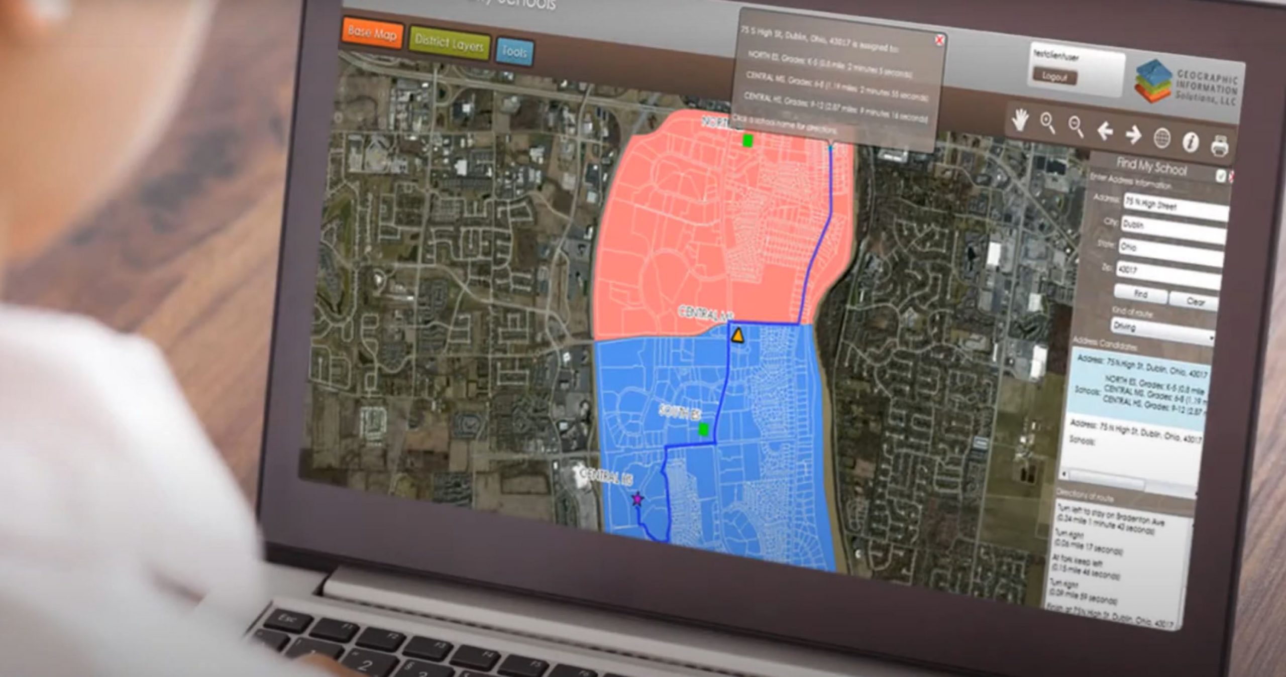
Find My School Planning Tool
Find My School™ and Bus Stop from Geographic Information Solutions, LLC provides an updated district map for both school administrators and students (as well as their parents). Students and parents have the capability to find addresses and landmarks near their school site and can easily get directions to school or find the closest bus stop. Any school boundary change or new address is quickly updated when the information becomes available.
Emergency Response Plans
GIS information technology can also help districts with efficient school planning during crisis or otherwise unforeseen circumstances.
GIS technology gives planners an accurate sense of the land and infrastructure in the area, which allows schools to properly write disaster recovery plans. GIS maps show the type of land and most common natural disasters prone to the area (for example, lava flows during volcanic eruptions in Hawaii). This detailed information helps schools create disaster plans for the emergencies that are most likely to occur in the area (and then determine a plan of action when they occur).
Similarly, if an incident were to happen at the school, an updated map helps plan a course of action for escape routes or safe spaces following evacuation.
GIS, LLC for All Your School Planning Needs
Geographic Information Solutions, LLC’s leadership has 20 years of experience in geographic information systems and 17 years of educational consulting experience. It’s the best GIS technology to help your school district needs!
GIS has four major products and services:
- Find My School™ and Bus Stop
- BEST Redistricting Tool (Boundary Exploration & Scenario Testing)
- Violation & Inspection Reporting Apps
- Consulting
The experts at Geographic Information Solutions, LLC are available for consultation for your school district’s particular needs, and no matter the problem, big or small, GIS, LLC can find the solution.
- School district demographics and analysis
- Attendance boundary planning
- Custom web-based maps
- Custom mobile mapping and app development
- Online storefronts and inventory tracking
We’re here to help your district plan for success. School planning with GIS technology has all the benefits you’re looking for. Contact us today and get started!